Luxor is called the City of the Hundred Gates or the City of the Sun, formerly known as Thebes. Between latitudes 25-26 N, 32-33 E, and it is about 670 km away from the Egyptian capital, Cairo, and about 220 km north of Aswan, about 56 km south of Qena, and about 280 km southwest of Hurghada, It is bordered to the north by the Qus Center and Qena Governorate, to the south by Edfu Center and Aswan Governorate, to the east by the Red Sea Governorate, and to the west by the Armant Center and the New Valley Governorate, The nearest seaport to the city is the port of Safaga, and the nearest airport to it is Luxor Airport. international.
Natural and tourist attractions
Eastern mainland
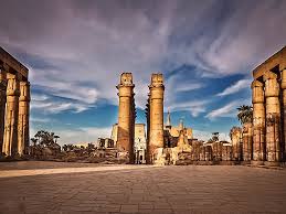
Luxor temple
Luxor International Airport
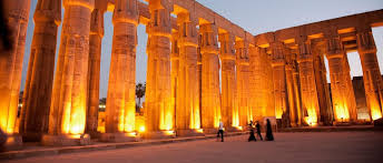
Karnak Temple
Luxor Museum
Taxidermy Museum
Panoramic view of the Great Column Hall at Karnak Temple in the Temple of Amun-Re area
Panoramic view of the Great Column Hall at Karnak Temple in the Temple of Amun-Re area
Western mainland
Valley of the Kings
Valley of the Queens
Medinet Habu Temple (memorial temple of King Ramses III)
Ramesseum Temple (memorial temple of King Ramesses II)
Deir el-Medina (the seat of families of workers and artisans during the era of the New Kingdom of Egypt)
Tombs of the Nobles
Deir el-Bahari (the mortuary temple of Hatshepsut, and other temples..)
Al-Malqta (Remains of Amenhotep III’s Palace)
Colossi of Memnon (all that remains of the memorial temple of Pharaoh Amenhotep III)
Education
The health
There are Luxor International Hospital, Luxor General Hospital, Central Bayadiya Hospital, Central Qurna, Central Armant, and many private hospitals.
Gardens
Nubian city
hotels
There are a lot of floating hotels and a branch of the Hilton, Sheraton, Habiba Hotel, Meriden Hotel, Mercure Hotel, Isis Hotel, Sonesta Hotel, Winter Palace Hotel, Iberotel Luxor Hotel, and Steigenburger Hotel.
Sports
Rowing Club for Water Sports, Al-Madina Sports Club and Luxor Sports Club, and it has many sports stadiums and youth centers such as Al-Madinah Al-Munawwarah Stadium and Al-Shaab Club Stadium. The governorate represents its own and independent club.
transportation
Air transport
Luxor International Airport
Luxor International Airport
The city of Luxor is served by Luxor International Airport, located 6 km east of the city and can receive tourists from different parts of the world in large numbers (about one million tourists annually). The airport is undergoing continuous development operations commensurate with its important and distinguished location.
The work of developing the old Luxor Airport began in 1984 and opened in 2005 at a cost of 450 million pounds. The capacity of the airport increased from 800 passengers per hour to 4000 passengers per hour, with a total of 7.5 million passengers annually, and from 21 aircraft to 33 aircraft.
river transport
Tourist floats
Indigo sandals
The river transport sector is one of the most important elements of the transportation system within Luxor with all its elements, whether navigational lines, Nile anchors, navigational locks, and the infrastructure of the navigational course, which serves tourist floats operating between Luxor and Aswan, as well as transport barges, sailing boats, and ferries.
There are also “river ferries”, which are large boats that transport the people of the governorate and tourists to and from the eastern and western ports at nominal prices, in addition to small private boats (owned by people) that are used for transportation and leisure in the middle of the Nile River.
The large cruise ships that provide Nile cruises from Cairo to Aswan pass through the Luxor Nile Marinas. This line is also used for the transport of goods and allows for double passage of the river units.
Road transport
Luxor connects the rest of the cities and governorates of Egypt with several land axes. The northern axes begin to connect with the closest governorates to Luxor, which is Qena. From Qena, the axes branch off. It can be linked east with the Qena/Safaga road to reach the Red Sea, and from Safaga to Hurghada, or north with the Qena/Sohag road. Then the Sohag / Assiut road, then the Assiut / Cairo road, and the northern axes pass through the same stations or cities on two desert and agricultural areas distributed east and west, and are represented by the eastern desert level road, the western desert level road, the agricultural level road, the Karimat road, and to the south using the axes of Upper Egypt Eastern and Western to connect with Aswan.